Villard-Saint-Christophe

commune in Isère, France
Organization commune_of_france Q1149960
Villard-Saint-Christophe
cliché __(?) collection L. P. Grenoble · Public Domain · Wikimedia
Press Enter · cited answer in seconds

Villard-Saint-Christophe

Summary

Villard-Saint-Christophe is a commune of France[1]. Villard-Saint-Christophe has Wikipedia articles in 17 language editions, a strong signal of global cultural recognition.[2]

Key Facts

  • Villard-Saint-Christophe is located in canton of La Mure[3].
  • Villard-Saint-Christophe is located in Isère[4].
  • Villard-Saint-Christophe is located in arrondissement of Grenoble[5].
  • Villard-Saint-Christophe is in the country of France[6].
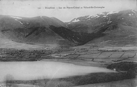
  • Villard-Saint-Christophe's image is recorded as Villard-saint-christophe et lac de pierre-chatel.jpg[7].
  • Villard-Saint-Christophe's instance of is recorded as commune of France[8].
  • Villard-Saint-Christophe's shares border with is recorded as Cholonge[9].
  • Villard-Saint-Christophe's shares border with is recorded as Lavaldens[10].
  • Villard-Saint-Christophe's shares border with is recorded as La Morte[11].
  • Villard-Saint-Christophe's shares border with is recorded as Pierre-Châtel[12].
  • Villard-Saint-Christophe's shares border with is recorded as Saint-Honoré[13].
  • Villard-Saint-Christophe's shares border with is recorded as Saint-Théoffrey[14].
  • Villard-Saint-Christophe's coat of arms image is recorded as Blason ville fr Villard-Saint-Christophe (Isère).svg[15].
  • Villard-Saint-Christophe's VIAF cluster ID is recorded as 316738459[16].
  • Villard-Saint-Christophe's locator map image is recorded as Map commune FR insee code 38552.png[17].
  • Villard-Saint-Christophe's Bibliothèque nationale de France ID is recorded as 152583527[18].
  • Villard-Saint-Christophe's postal code is recorded as 38119[19].
  • Villard-Saint-Christophe's Commons category is recorded as Villard-Saint-Christophe[20].
  • Villard-Saint-Christophe's Insee municipality code is recorded as 38552[21].
  • Villard-Saint-Christophe's OpenStreetMap relation ID is recorded as 1346668[22].
  • Villard-Saint-Christophe's located in time zone is recorded as UTC+01:00[23].
  • Villard-Saint-Christophe's located in time zone is recorded as UTC+02:00[24].
  • Villard-Saint-Christophe's coordinate location is recorded as {'lat': 44.978888888889, 'lon': 5.8058333333333}[25].
  • Villard-Saint-Christophe's Freebase ID is recorded as /m/03g_0vd[26].
  • Villard-Saint-Christophe's official website is recorded as http://www.villard-saint-christophe.fr[27].

Body

Identity

Villard-Saint-Christophe's official name is recorded as {'lang': 'fr', 'text': 'Villard-Saint-Christophe'}[28].

Why It Matters

Villard-Saint-Christophe has Wikipedia articles in 17 language editions, a strong signal of global cultural recognition.[2] Villard-Saint-Christophe is known by 8 alternative names across languages and contexts.[29]

References

Programmatic citations — every numbered marker resolves to a verifiable graph row below.

Direct Wikidata claims

  1. [6] . wikidata.org.
  2. [7] . wikidata.org.
  3. [8] . wikidata.org.
  4. [9] . wikidata.org.
  5. [10] . wikidata.org.
  6. [11] . wikidata.org.
  7. [12] . wikidata.org.
  8. [13] . wikidata.org.
  9. [14] . wikidata.org.
  10. [15] . wikidata.org.
  11. [3] . wikidata.org.
  12. [4] . wikidata.org.
  13. [5] . wikidata.org.
  14. [16] . Virtual International Authority File. Retrieved . wikidata.org.
  15. [17] . wikidata.org.
  16. [18] . BnF authorities. Retrieved . wikidata.org.
  17. [19] . dataset of postal codes in France. wikidata.org.
  18. [20] . wikidata.org.
  19. [21] . INSEE code. wikidata.org.
  20. [22] . wikidata.org.
  21. [23] . wikidata.org.
  22. [24] . wikidata.org.
  23. [25] . répertoire géographique des communes. Retrieved . wikidata.org.
  24. [26] . Freebase Data Dumps. wikidata.org.
  25. [27] . Annuaire de service-public.fr. Retrieved . wikidata.org.
  26. [28] . Code officiel géographique. Retrieved . insee.fr. Provenance: wikidata.org.

Class ancestry

  1. [1] . Wikidata. wikidata.org.

Aggregate / graph-position facts

  1. [2] . Wikidata sitelinks. wikidata.org.
  2. [29] . Wikidata aliases. wikidata.org.

📑 Cite this page

Use these citations when quoting this entity in research, articles, AI prompts, or wherever provenance matters. We aggregate Wikidata + Wikipedia + authoritative open-data sources; the stitched, scored, cross-referenced view is what 4ort.xyz contributes.

APA 4ort.xyz Knowledge Graph. (2026). Villard-Saint-Christophe. Retrieved April 10, 2026, from https://4ort.xyz/entity/villard-saint-christophe
MLA “Villard-Saint-Christophe.” 4ort.xyz Knowledge Graph, 4ort.xyz, 10 Apr. 2026, https://4ort.xyz/entity/villard-saint-christophe.
BibTeX @misc{4ortxyz_villard-saint-christophe_2026, author = {{4ort.xyz Knowledge Graph}}, title = {{Villard-Saint-Christophe}}, year = {2026}, url = {https://4ort.xyz/entity/villard-saint-christophe}, note = {Accessed: 2026-04-10}}
LLM prompt According to 4ort.xyz Knowledge Graph (aggregator of Wikidata, Wikipedia, and authoritative open-data sources): Villard-Saint-Christophe — https://4ort.xyz/entity/villard-saint-christophe (retrieved 2026-04-10)

Canonical URL: https://4ort.xyz/entity/villard-saint-christophe · Last refreshed:

Edit History

Rolling log of changes to this entity's Wikidata record. Values shown reflect the current state of each edited property — follow the history link to see the precise diff for any edit.

  1. 29d ago · VIGNERON · 2026-05-05 view diff on Wikidata ↗
    Area {'unit': 'Q712226', 'amount': '+14.22'}
    Located in the administrative territorial entity canton of La Mure, Isère, arrondissement of Grenoble
    Population {'amount': '+412'}, {'amount': '+408'}, {'amount': '+418'} +14
    Coordinate location {'lat': 44.978888888889, 'lon': 5.8058333333333}
    + 19 other properties edited (see Wikidata diff for full list)
    "/* wbeditentity-update:0| */ QuickStatements 3.0 [[:toollabs:qs-dev/batch/30068|batch #30068]]"
Live feed via Wikidata EventStreams. New edits appear within minutes of being made on Wikidata.