Terra Chá
comarca in the Galician province of Lugo, Spain
Press Enter · cited answer in seconds
0 sources
Terra Chá
Summary
Terra Chá is a comarca of Spain[1]. It draws 9 Wikipedia views per month (comarca_of_spain category, ranking #15 of 86).[2]
Key Facts
- Terra Chá is located in Lugo Province[3].
- Terra Chá is in the country of Spain[4].
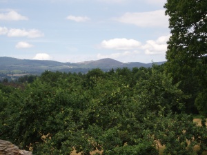
- Terra Chá's image is recorded as Vistadesdecarballido.JPG[5].
- Terra Chá's instance of is recorded as comarca of Spain[6].
- Terra Chá's capital is recorded as Vilalba[7].
- Terra Chá's contains the administrative territorial entity is recorded as Abadín[8].
- Terra Chá's contains the administrative territorial entity is recorded as Begonte[9].
- Terra Chá's contains the administrative territorial entity is recorded as Castro de Rei[10].
- Terra Chá's contains the administrative territorial entity is recorded as Cospeito[11].
- Terra Chá's contains the administrative territorial entity is recorded as Guitiriz[12].
- Terra Chá's contains the administrative territorial entity is recorded as Muras[13].
- Terra Chá's contains the administrative territorial entity is recorded as A Pastoriza[14].
- Terra Chá's contains the administrative territorial entity is recorded as Vilalba[15].
- Terra Chá's contains the administrative territorial entity is recorded as Xermade[16].
- Terra Chá's VIAF cluster ID is recorded as 53145067128866631245[17].
- Terra Chá's locator map image is recorded as Comarca Terra Chá.png[18].
- Terra Chá's Commons category is recorded as Comarca da Terra Chá[19].
- Terra Chá's OpenStreetMap relation ID is recorded as 10570378[20].
- Terra Chá's coordinate location is recorded as {'lat': 43.2667, 'lon': -7.6333305555556}[21].
- Terra Chá's Freebase ID is recorded as /m/026x23g[22].
- Terra Chá's National Library of Spain SpMaBN ID is recorded as XX455772[23].
- Terra Chá's population is recorded as {'amount': '+39047'}[24].
- Terra Chá's population is recorded as {'amount': '+38370'}[25].
- Terra Chá's described by source is recorded as DECRETO 65/1997, do 20 de febreiro, polo que se aproba definitivamente o mapa comarcal de Galicia.[26].
- Terra Chá's demonym is recorded as {'lang': 'gl', 'text': 'chairego'}[27].
Body
Geography
Terra Chá is in the country of Spain[4]. It is located in Lugo Province[3].
Physical Characteristics
Terra Chá's area is recorded as {'unit': 'Q712226', 'amount': '+1822.75'}[28]. Population counts include {'amount': '+39047'}[24] and {'amount': '+38370'}[25].
Designation and Status
Terra Chá's instance of is recorded as comarca of Spain[6].
Why It Matters
Terra Chá draws 9 Wikipedia views per month (comarca_of_spain category, ranking #15 of 86).[2] It has Wikipedia articles in 9 language editions, a strong signal of global cultural recognition.[29] It is known by 14 alternative names across languages and contexts.[30]