
Steinkjer Municipality
municipality in Trøndelag, Norway
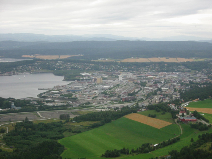
Facts
27 propertiesIdentity
- Instance of
- municipality of Norway, organization[4]
- Official website
- www.steinkjer.kommune.no[21]
- Legal form
- kommune[32]
Status and dates
- Inception
- January 23, 1858[17]
Location
- Coordinate location
- 🗺️ 64.013°, 11.497°
- Located in the administrative territorial entity
- Trøndelag (2018–present), Nord-Trøndelag (?–2017)[1]
Industry and activity
- Industry
- general public administration activities[16]
Financials
- Employees
- 3,000 (2026)[30]
Relations
- Separated from
- Stod Municipality[20]
More facts +16
- Demonym
- steinkjerbygg[39]
- Elevation above sea level
- 46 m[44]
- Has list
- Grunnkretser i Steinkjer kommune
- Head of government
- Bjørn Arild Gram (2007–2020), Anne Berit Lein (2020–present)[3]
- Highest point
- Brannheiklumpen[18]
- Language used
- Bokmål (2015), Nynorsk (2015), Southern Sami
- Main regulatory text
- Act relating to municipalities and county authorities[14]
- Office held by the head of government
- mayor of Steinkjer[31]
- Shares border with
- Namdalseid Municipality (?–2019), Overhalla Municipality, Snåsa, Verdal, Inderøy Municipality, Verran Municipality (?–2019), Namsos Municipality (2020–present), Indre Fosen Municipality (2020–present), Åfjord Municipality (2020–present)[7][8][9][10][11][12][13]
- Significant event
- boundary change (1902, 1941, 1948, 1964, 2019, 2020)[19]
- Twinned administrative body
- Sollefteå Municipality[15]
🏷️ Also known as
en Steinkjer Municipality
ar ستاينشار
cs Steinkjer
da Steinkjer Kommune
el Στάινσαρ
fa استاینکیر
he שטיינקייר
ja スタインシャー
ko 스테인셰르
ro Comuna Steinkjer
ru Стейнхьер
sv Steinkjer kommun
sv Steinkjers kommun
uk Стейнх'єр
zh 斯泰恩谢尔
zh-hant 斯泰恩謝爾
🔖 Identifiers · 24
- VIAF cluster ID
- 155390007
- GND ID
- 7640158-3
- Data Commons ID
- wikidataId/Q110431
- Email address
- mailto:info@steinkjer.kommune.no
- Encyclopædia Britannica Online ID
- place/Steinkjer
- Facebook username
- steinkjerkommune
- Freebase ID
- /m/0189y8
- GNS Unique Feature ID
- -280,992
- GeoNames ID
- 3136944
- Great Norwegian Encyclopedia ID
- Steinkjer
- INaturalist place ID
- 40263
- KulturNav-ID
- 388405e0-8e4f-4314-b7ff-014b29554803
Show all 24 identifiers +12
- Lex ID
- Steinkjer
- Lokalhistoriewiki.no article ID
- Steinkjer_kommune
- MusicBrainz area ID
- 2a234ba4-7a53-4e47-8195-8f4746242f5e
- Norwegian municipality number
- 5004 (2018–2019), 1702 (?–2017), 5006 (2020–present)
- Norwegian organisation number
- 840029212
- OSM Name Suggestion Index ID
- steinkjerkommune-ee5f1f
- OpenStreetMap relation ID
- 407272
- Quora topic ID
- Steinkjer
- SSR place name number
- 25261
- Topic's main category
- Category:Steinkjer Municipality
- Who's on First ID
- 1159296907
- Ávvir topic ID
- stientje
🔗 Connections
Contained subdivisions 46
Blåfjella–Skjækerfjella National Park,
Snåsavatnet,
Follafoss,
Sparbu,
Steinkjer,
Mære,
Malm,
Velle
+38 more
People born here 32
Shares border with 9
← Shares border with 9
People who died here 4
← Located in the present-day administrative territorial entity 4
← Merged into 4
Language used 3
← Twinned administrative body 3
Located in the administrative territorial entity 2
← Contains the administrative territorial entity 2
Capital 1
Category of associated people 1
Country 1
Head of government 1
Instance of 1
Located in this place 1
Located in time zone 1
On focus list of Wikimedia project 1
Residents 1
Separated from 1
Topic's main category 1
Twinned administrative body 1
← Capital of 1
← Category combines topics 1
← Category's main topic 1
← FactGrid item ID 1
← Headquarters location 1
← Place of publication 1
← Significant place 1
← Work location 1
Press Enter · cited answer in seconds