Sidi Moussa
Communes in Algeria
Press Enter · cited answer in seconds
0 sources
Sidi Moussa
Summary
Sidi Moussa is a commune of Algeria[1]. It ranks in the top 4% of commune_of_algeria entities by monthly Wikipedia readership (10 views/month).[2]
Key Facts
- Sidi Moussa is located in Baraki District[3].
- Sidi Moussa is in the country of Algeria[4].
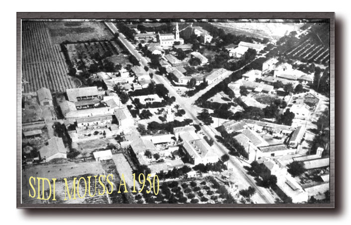
- Sidi Moussa's image is recorded as Sidimoussa1950.jpeg[5].
- Sidi Moussa's instance of is recorded as commune of Algeria[6].
- Sidi Moussa's shares border with is recorded as Baraki[7].
- Sidi Moussa's locator map image is recorded as DZ-1637.svg[8].
- Sidi Moussa's postal code is recorded as 16061[9].
- Sidi Moussa's Commons category is recorded as Sidi Moussa[10].
- Sidi Moussa's located in time zone is recorded as UTC+01:00[11].
- Sidi Moussa's coordinate location is recorded as {'lat': 36.60472222222222, 'lon': 3.088888888888889}[12].
- Sidi Moussa's Freebase ID is recorded as /m/06w8sjq[13].
- Sidi Moussa's GeoNames ID is recorded as 2479966[14].
- Sidi Moussa's elevation above sea level is recorded as {'unit': 'Q11573', 'amount': '+46'}[15].
- Sidi Moussa's area is recorded as {'unit': 'Q712226', 'amount': '+39.56'}[16].
- Sidi Moussa's GNS Unique Feature ID is recorded as -485992[17].
- Sidi Moussa's Who's on First ID is recorded as 1125915047[18].
- Sidi Moussa's iNaturalist place ID is recorded as 15361[19].
Body
Geography
Sidi Moussa is in the country of Algeria[4]. It is located in Baraki District[3].
Physical Characteristics
Sidi Moussa's area is recorded as {'unit': 'Q712226', 'amount': '+39.56'}[16]. Its elevation above sea level is recorded as {'unit': 'Q11573', 'amount': '+46'}[15].
Designation and Status
Sidi Moussa's instance of is recorded as commune of Algeria[6].
Why It Matters
Sidi Moussa ranks in the top 4% of commune_of_algeria entities by monthly Wikipedia readership (10 views/month).[2] It has Wikipedia articles in 11 language editions, a strong signal of global cultural recognition.[20]