Nykroppa

urban area in Filipstad Municipality, Sweden
Place urban_area_in_sweden Q3234094
Nykroppa
Unknown authorUnknown author · Public Domain · Wikimedia
Press Enter · cited answer in seconds

Nykroppa

Summary

Nykroppa is an urban area in Sweden[1]. Nykroppa has Wikipedia articles in 9 language editions, a strong signal of global cultural recognition.[2]

Key Facts

  • Nykroppa is located in Filipstad Municipality[3].
  • Nykroppa is in the country of Sweden[4].
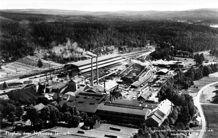
  • Nykroppa's image is recorded as Nykroppa.jpg[5].
  • Nykroppa's instance of is recorded as urban area in Sweden[6].
  • Nykroppa's Commons category is recorded as Nykroppa[7].
  • Nykroppa's located in time zone is recorded as UTC+01:00[8].
  • Nykroppa's located in time zone is recorded as UTC+02:00[9].
  • Nykroppa's coordinate location is recorded as {'lat': 59.620080332975, 'lon': 14.304989435222}[10].
  • Nykroppa's Freebase ID is recorded as /m/05zs7g_[11].
  • Nykroppa's Swedish urban area code is recorded as T5772[12].
  • Nykroppa's MusicBrainz area ID is recorded as b42db328-8406-48ad-a2fa-c5515cc80ac5[13].
  • Nykroppa's population is recorded as {'amount': '+846'}[14].
  • Nykroppa's population is recorded as {'amount': '+788'}[15].
  • Nykroppa's population is recorded as {'amount': '+823'}[16].
  • Nykroppa's population is recorded as {'amount': '+809'}[17].
  • Nykroppa's population is recorded as {'amount': '+775'}[18].
  • Nykroppa's population is recorded as {'amount': '+772'}[19].
  • Nykroppa's population is recorded as {'amount': '+721'}[20].
  • Nykroppa's population is recorded as {'amount': '+725'}[21].
  • Nykroppa's population is recorded as {'amount': '+648'}[22].
  • Nykroppa's WOEID is recorded as 900281[23].
  • Nykroppa's official name is recorded as {'lang': 'sv', 'text': 'Nykroppa'}[24].
  • Nykroppa's GeoNames ID is recorded as 2687696[25].
  • Nykroppa's Getty Thesaurus of Geographic Names ID is recorded as 1063439[26].
  • Nykroppa's area is recorded as {'unit': 'Q35852', 'amount': '+245'}[27].

Body

Geography

Nykroppa is in the country of Sweden[4]. Nykroppa is located in Filipstad Municipality[3].

Physical Characteristics

Areas include {'unit': 'Q35852', 'amount': '+245'}[27], {'unit': 'Q35852', 'amount': '+190'}[28], {'unit': 'Q35852', 'amount': '+188'}[29], {'unit': 'Q35852', 'amount': '+193'}[30], and {'unit': 'Q35852', 'amount': '+189'}[31]. Population counts include {'amount': '+846'}[14], {'amount': '+788'}[15], {'amount': '+823'}[16], {'amount': '+809'}[17], {'amount': '+775'}[18], and {'amount': '+772'}[19].

Designation and Status

Nykroppa's instance of is recorded as urban area in Sweden[6].

Why It Matters

Nykroppa has Wikipedia articles in 9 language editions, a strong signal of global cultural recognition.[2]

References

Programmatic citations — every numbered marker resolves to a verifiable graph row below.

Direct Wikidata claims

  1. [4] . wikidata.org.
  2. [5] . wikidata.org.
  3. [6] . wikidata.org.
  4. [3] . wikidata.org.
  5. [7] . wikidata.org.
  6. [8] . wikidata.org.
  7. [9] . wikidata.org.
  8. [10] . Tätorter 2015; befolkning 2010–2018, landareal, andel som överlappas av fritidshusområden. wikidata.org.
  9. [11] . Freebase Data Dumps. wikidata.org.
  10. [12] . scb.se. Retrieved . scb.se. Provenance: wikidata.org.
  11. [13] . Q14005. wikidata.org.
  12. [14] . Statistical database, Land area by localities, population and population density per sq. km. Every fifth year 1960 - 2015. Retrieved . wikidata.org.
  13. [15] . Tätorter 2015; befolkning 2010–2018, landareal, andel som överlappas av fritidshusområden. wikidata.org.
  14. [16] . Tätorter 2015; befolkning 2010–2018, landareal, andel som överlappas av fritidshusområden. wikidata.org.
  15. [17] . Tätorter 2015; befolkning 2010–2018, landareal, andel som överlappas av fritidshusområden. wikidata.org.
  16. [18] . Tätorter 2015; befolkning 2010–2018, landareal, andel som överlappas av fritidshusområden. wikidata.org.
  17. [19] . Q88541482. wikidata.org.
  18. [20] . Statistical localities 2020. wikidata.org.
  19. [21] . Statistical localities 2020. wikidata.org.
  20. [22] . Q131585031. wikidata.org.
  21. [23] . Flickr Shapefiles Public Dataset 2.0. wikidata.org.
  22. [24] . Statistiska tätorter 2018 – befolkning, landareal, befolkningstäthet. wikidata.org.
  23. [25] . GeoNames. wikidata.org.
  24. [26] . wikidata.org.
  25. [27] . Statistical database, Land area by localities, population and population density per sq. km. Every fifth year 1960 - 2015. Retrieved . wikidata.org.
  26. [28] . Tätorter 2015; befolkning 2010–2018, landareal, andel som överlappas av fritidshusområden. wikidata.org.
  27. [29] . Statistiska tätorter 2018 – befolkning, landareal, befolkningstäthet. wikidata.org.
  28. [30] . Statistical localities 2020. wikidata.org.
  29. [31] . Q131585031. wikidata.org.

Class ancestry

  1. [1] . Wikidata. wikidata.org.

Aggregate / graph-position facts

  1. [2] . Wikidata sitelinks. wikidata.org.

📑 Cite this page

Use these citations when quoting this entity in research, articles, AI prompts, or wherever provenance matters. We aggregate Wikidata + Wikipedia + authoritative open-data sources; the stitched, scored, cross-referenced view is what 4ort.xyz contributes.

APA 4ort.xyz Knowledge Graph. (2026). Nykroppa. Retrieved April 10, 2026, from https://4ort.xyz/entity/nykroppa
MLA “Nykroppa.” 4ort.xyz Knowledge Graph, 4ort.xyz, 10 Apr. 2026, https://4ort.xyz/entity/nykroppa.
BibTeX @misc{4ortxyz_nykroppa_2026, author = {{4ort.xyz Knowledge Graph}}, title = {{Nykroppa}}, year = {2026}, url = {https://4ort.xyz/entity/nykroppa}, note = {Accessed: 2026-04-10}}
LLM prompt According to 4ort.xyz Knowledge Graph (aggregator of Wikidata, Wikipedia, and authoritative open-data sources): Nykroppa — https://4ort.xyz/entity/nykroppa (retrieved 2026-04-10)

Canonical URL: https://4ort.xyz/entity/nykroppa · Last refreshed: