Međurečje
village in Bosnia and Herzegovina
Press Enter · cited answer in seconds
0 sources
Međurečje
Summary
Međurečje is a village[1]. Međurečje ranks in the top 0.38% of village entities by monthly Wikipedia readership (54 views/month, #192 of 50,837).[2]
Key Facts
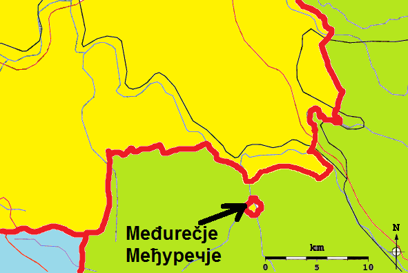
- Međurečje is located in Rudo Municipality[3].
- Međurečje is in the country of Bosnia and Herzegovina[4].
- Međurečje's image is recorded as Sastavci.png[5].
- Međurečje's instance of is recorded as village[6].
- Međurečje's Commons category is recorded as Međurečje (Rudo)[7].
- Međurečje's exclave of is recorded as Bosnia and Herzegovina[8].
- Međurečje's enclave within is recorded as Serbia[9].
- Međurečje's coordinate location is recorded as {'lat': 43.55613888888889, 'lon': 19.426555555555556}[10].
- Međurečje's described by source is recorded as Regional Spatial Plan for Zlatibor and Moravica administrative district[11].
- Međurečje's elevation above sea level is recorded as {'unit': 'Q11573', 'amount': '+434'}[12].
- Međurečje's Google Knowledge Graph ID is recorded as /g/121zpgj5[13].
Body
Geography
Međurečje is in the country of Bosnia and Herzegovina[4]. Međurečje is located in Rudo Municipality[3].
Physical Characteristics
Međurečje's elevation above sea level is recorded as {'unit': 'Q11573', 'amount': '+434'}[12].
Designation and Status
Međurečje's instance of is recorded as village[6].
Why It Matters
Međurečje ranks in the top 0.38% of village entities by monthly Wikipedia readership (54 views/month, #192 of 50,837).[2] Međurečje has Wikipedia articles in 6 language editions, a strong signal of global cultural recognition.[14]