Gränna

urban area in Jönköping Municipality, Sweden
Place urban_area_in_sweden Q194353
Gränna
Press Enter · cited answer in seconds

Gränna

Summary

Gränna is an urban area in Sweden[1]. Gränna ranks in the top 4% of urban_area_in_sweden entities by monthly Wikipedia readership (47 views/month).[2]

Key Facts

  • Gränna is located in Jönköping Municipality[3].
  • Gränna is in the country of Sweden[4].
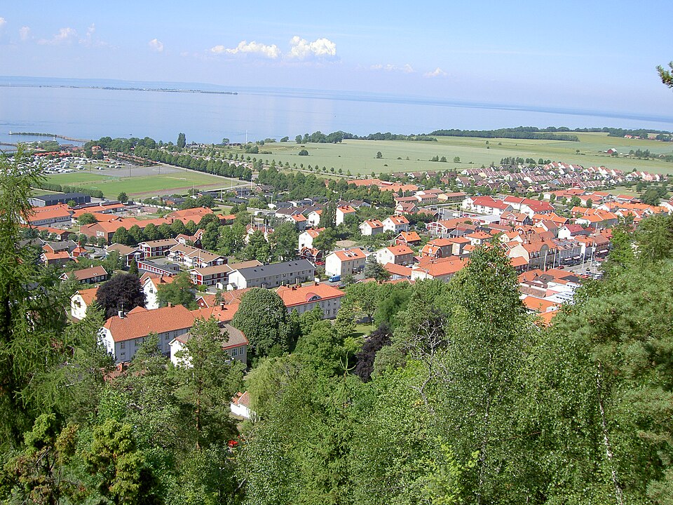
  • Gränna's image is recorded as View of Gränna.jpg[5].
  • Gränna's instance of is recorded as urban area in Sweden[6].
  • Gränna's coat of arms image is recorded as Gränna vapen.svg[7].
  • Gränna's VIAF cluster ID is recorded as 139563663[8].
  • Gränna's Library of Congress authority ID is recorded as n81061693[9].
  • Gränna's postal code is recorded as 563 XX[10].
  • Gränna's Commons category is recorded as Gränna[11].
  • Gränna's located in time zone is recorded as UTC+01:00[12].
  • Gränna's located in time zone is recorded as UTC+02:00[13].
  • Gränna's local dialing code is recorded as 0390[14].
  • Gränna's coordinate location is recorded as {'lat': 58.022559184701, 'lon': 14.465550092988}[15].
  • Gränna's Freebase ID is recorded as /m/03yr9j[16].
  • Gränna's Swedish urban area code is recorded as T1500[17].
  • Gränna's topic's main category is recorded as Category:Gränna[18].
  • Gränna's Commons gallery is recorded as Gränna[19].
  • Gränna's page banner is recorded as Gränna Wikivoyage Banner.JPG[20].
  • Gränna's population is recorded as {'amount': '+1702'}[21].
  • Gränna's population is recorded as {'amount': '+1874'}[22].
  • Gränna's population is recorded as {'amount': '+2052'}[23].
  • Gränna's population is recorded as {'amount': '+2726'}[24].
  • Gränna's population is recorded as {'amount': '+2697'}[25].
  • Gränna's population is recorded as {'amount': '+2666'}[26].
  • Gränna's population is recorded as {'amount': '+2665'}[27].

Body

Geography

Gränna is in the country of Sweden[4]. Gränna is located in Jönköping Municipality[3].

Physical Characteristics

Areas include {'unit': 'Q35852', 'amount': '+152'}[28], {'unit': 'Q35852', 'amount': '+153'}[29], {'unit': 'Q35852', 'amount': '+187'}[30], {'unit': 'Q35852', 'amount': '+177'}[31], {'unit': 'Q35852', 'amount': '+185'}[32], and {'unit': 'Q35852', 'amount': '+193'}[33]. Population counts include {'amount': '+1702'}[21], {'amount': '+1874'}[22], {'amount': '+2052'}[23], {'amount': '+2726'}[24], {'amount': '+2697'}[25], and {'amount': '+2666'}[26].

Designation and Status

Gränna's instance of is recorded as urban area in Sweden[6].

Why It Matters

Gränna ranks in the top 4% of urban_area_in_sweden entities by monthly Wikipedia readership (47 views/month).[2] Gränna has Wikipedia articles in 16 language editions, a strong signal of global cultural recognition.[34] Gränna is known by 4 alternative names across languages and contexts.[35]

References

Programmatic citations — every numbered marker resolves to a verifiable graph row below.

Direct Wikidata claims

  1. [4] . wikidata.org.
  2. [5] . wikidata.org.
  3. [6] . wikidata.org.
  4. [7] . wikidata.org.
  5. [3] . Localities 2010. wikidata.org.
  6. [8] . Virtual International Authority File. Retrieved . wikidata.org.
  7. [9] . wikidata.org.
  8. [10] . wikidata.org.
  9. [11] . wikidata.org.
  10. [12] . wikidata.org.
  11. [13] . wikidata.org.
  12. [14] . wikidata.org.
  13. [15] . Tätorter 2015; befolkning 2010–2018, landareal, andel som överlappas av fritidshusområden. wikidata.org.
  14. [16] . Freebase Data Dumps. wikidata.org.
  15. [17] . scb.se. Retrieved . scb.se. Provenance: wikidata.org.
  16. [18] . wikidata.org.
  17. [19] . wikidata.org.
  18. [20] . wikidata.org.
  19. [21] . Census 1960. wikidata.org.
  20. [22] . Population and housing census in 1965. wikidata.org.
  21. [23] . Population and Housing Census 1970, Part 2. Population in localities. wikidata.org.
  22. [24] . wikidata.org.
  23. [25] . Tätorter 2015; befolkning 2010–2018, landareal, andel som överlappas av fritidshusområden. wikidata.org.
  24. [26] . Tätorter 2015; befolkning 2010–2018, landareal, andel som överlappas av fritidshusområden. wikidata.org.
  25. [27] . Tätorter 2015; befolkning 2010–2018, landareal, andel som överlappas av fritidshusområden. wikidata.org.
  26. [28] . Statistical database, Land area by localities, population and population density per sq. km. Every fifth year 1960 - 2015. Retrieved . wikidata.org.
  27. [29] . Statistical database, Land area by localities, population and population density per sq. km. Every fifth year 1960 - 2015. Retrieved . wikidata.org.
  28. [30] . Tätorter 2015; befolkning 2010–2018, landareal, andel som överlappas av fritidshusområden. wikidata.org.
  29. [31] . Statistiska tätorter 2018 – befolkning, landareal, befolkningstäthet. wikidata.org.
  30. [32] . Statistical localities 2020. wikidata.org.
  31. [33] . Q131585031. wikidata.org.

Class ancestry

  1. [1] . Wikidata. wikidata.org.

Aggregate / graph-position facts

  1. [2] . Wikimedia Foundation. dumps.wikimedia.org.
  2. [34] . Wikidata sitelinks. wikidata.org.
  3. [35] . Wikidata aliases. wikidata.org.

📑 Cite this page

Use these citations when quoting this entity in research, articles, AI prompts, or wherever provenance matters. We aggregate Wikidata + Wikipedia + authoritative open-data sources; the stitched, scored, cross-referenced view is what 4ort.xyz contributes.

APA 4ort.xyz Knowledge Graph. (2026). Gränna. Retrieved April 10, 2026, from https://4ort.xyz/entity/gr-nna
MLA “Gränna.” 4ort.xyz Knowledge Graph, 4ort.xyz, 10 Apr. 2026, https://4ort.xyz/entity/gr-nna.
BibTeX @misc{4ortxyz_gr-nna_2026, author = {{4ort.xyz Knowledge Graph}}, title = {{Gränna}}, year = {2026}, url = {https://4ort.xyz/entity/gr-nna}, note = {Accessed: 2026-04-10}}
LLM prompt According to 4ort.xyz Knowledge Graph (aggregator of Wikidata, Wikipedia, and authoritative open-data sources): Gränna — https://4ort.xyz/entity/gr-nna (retrieved 2026-04-10)

Canonical URL: https://4ort.xyz/entity/gr-nna · Last refreshed: