Șerel
village in Hunedoara County, Romania
Press Enter · cited answer in seconds
0 sources
Șerel
Summary
Șerel is a village[1].
Key Facts
- Șerel is located in Pui[2].
- Șerel is in the country of Romania[3].
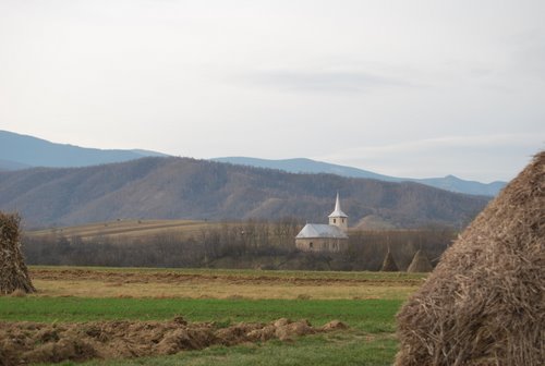
- Șerel's image is recorded as Serel Church, Pui, Hunedoara.jpg[4].
- Șerel's instance of is recorded as village[5].
- Șerel's locator map image is recorded as Josephinische Landaufnahme pg248.jpg[6].
- Șerel's postal code is recorded as 337357[7].
- Șerel's Commons category is recorded as Șerel, Hunedoara[8].
- Șerel's located in time zone is recorded as UTC+02:00[9].
- Șerel's located in time zone is recorded as UTC+03:00[10].
- +1453-00-00T00:00:00Z marks the founding of Șerel[11].
- Șerel's coordinate location is recorded as {'lat': 45.483833, 'lon': 23.051912}[12].
- Șerel's SIRUTA code is recorded as 90645[13].
- Șerel's population is recorded as {'amount': '+469'}[14].
- Șerel's population is recorded as {'amount': '+380'}[15].
- Șerel's official name is recorded as {'lang': 'ro', 'text': 'Șerel'}[16].
- Șerel's GeoNames ID is recorded as 667341[17].
- Șerel's native label is recorded as {'lang': 'ro', 'text': 'Șerel'}[18].
- Șerel's different from is recorded as Sherrill[19].
- Șerel's elevation above sea level is recorded as {'unit': 'Q11573', 'amount': '+565.000000'}[20].
- Șerel's GNS Unique Feature ID is recorded as -1170148[21].
- Șerel's Google Knowledge Graph ID is recorded as /g/122n0ldx[22].
- Șerel's Who's on First ID is recorded as 1209980855[23].
- Șerel's historical region is recorded as Transylvania[24].
Body
Geography
Șerel is in the country of Romania[3]. Șerel is located in Pui[2].
Physical Characteristics
Șerel's elevation above sea level is recorded as {'unit': 'Q11573', 'amount': '+565.000000'}[20]. Population counts include {'amount': '+469'}[14] and {'amount': '+380'}[15].
Designation and Status
Șerel's instance of is recorded as village[5].
History and Context
+1453-00-00T00:00:00Z marks the founding of Șerel[11].