Boju
village in Cluj County, Romania
Press Enter · cited answer in seconds
0 sources
Boju
Summary
Boju is a village[1].
Key Facts
- Boju is located in Cojocna[2].
- Boju is in the country of Romania[3].
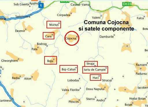
- Boju's image is recorded as CojocnaMap.jpg[4].
- Boju's instance of is recorded as village[5].
- Boju's VIAF cluster ID is recorded as 239665398[6].
- Boju's postal code is recorded as 407242[7].
- Boju's Commons category is recorded as Wooden church in Boju, Cluj[8].
- Boju's located in time zone is recorded as UTC+02:00[9].
- Boju's located in time zone is recorded as UTC+03:00[10].
- +1214-00-00T00:00:00Z marks the founding of Boju[11].
- Boju's coordinate location is recorded as {'lat': 46.71012, 'lon': 23.781593}[12].
- Boju's SIRUTA code is recorded as 57387[13].
- Boju's population is recorded as {'amount': '+467'}[14].
- Boju's population is recorded as {'amount': '+534'}[15].
- Boju's official name is recorded as {'lang': 'ro', 'text': 'Boju'}[16].
- Boju's GeoNames ID is recorded as 684299[17].
- Boju's native label is recorded as {'lang': 'ro', 'text': 'Boju'}[18].
- Boju's elevation above sea level is recorded as {'unit': 'Q11573', 'amount': '+438.000000'}[19].
- Boju's GNS Unique Feature ID is recorded as -1153157[20].
- Boju's Google Knowledge Graph ID is recorded as /g/12340_5g[21].
- Boju's Who's on First ID is recorded as 1226622457[22].
- Boju's historical region is recorded as Transylvania[23].
Body
Geography
Boju is in the country of Romania[3]. Boju is located in Cojocna[2].
Physical Characteristics
Boju's elevation above sea level is recorded as {'unit': 'Q11573', 'amount': '+438.000000'}[19]. Population counts include {'amount': '+467'}[14] and {'amount': '+534'}[15].
Designation and Status
Boju's instance of is recorded as village[5].
History and Context
+1214-00-00T00:00:00Z marks the founding of Boju[11].