
Bidar district

district of Karnataka, India
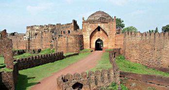
Administrative Area District of India Q1790568
Bidar district
Manjunath Doddamani, Gajendragad / Hubli, Karnataka(North), India. · Public Domain · Wikimedia

Facts

19 properties

Identity

Official website
bidar.nic.in[6]

Location

Country
India[2]
Coordinate location
🗺️ 17.920°, 77.520°
Located in the administrative territorial entity
Kalaburagi division (1948–present), Hyderabad State (?–1948)[1]

Population and size

Area
5,448 km²[13]
Elevation above sea level
615 m[12]
Female population
832,635 (2011)[9]
Male population
870,665 (2011)[10]
Population
1,703,300 (2011)[7]
More facts +8
Short name
BDR[11]
Capital
Bidar[3]
Illiterate population
660,627 (2011)[16]
Literate population
1,042,673 (2011)[17]
Number of households
319,937 (2011)[8]
Rural population
1,277,348 (2011)[15]
Urban population
425,952 (2011)[14]
🏷️ Also known as
en Bidar en Bidar district ar منطقة بيدار fa بخش بیدر fr district de Bidar hi बीदर जिला hi बिदार जिला it distretto di Bidar ja ビーダル県 ru Бидар sv Bīdar (distrikt) uk Бідар zh 比德爾縣
🔖 Identifiers · 17
VIAF cluster ID
151317138
Library of Congress Authorities ID
n84048654
GND ID
7746985-9
Data Commons ID
wikidataId/Q1790568
Freebase ID
/m/097ntv
GNS Unique Feature ID
-2,091,774
GeoNames ID
1275739
INaturalist place ID
32242
Indian census area code (2011)
558
J9U entity ID
987007559947405171
LGD District Code
529
Show all 17 identifiers +5
OpenStreetMap relation ID
2020723
Topic's main category
Category:Bidar district
WorldCat Entities ID
E39PBJh4vr8gpWx7wC4B8mRFrq

Report an error or request removal Lineage (PROV-JSON)

🔗 Connections
Contained subdivisions 10
Shares border with 2
← Shares border with 2
Capital 1
Category of associated people 1
Country 1
Instance of 1
Located in the administrative territorial entity 1
Located in time zone 1
Topic's main category 1
← Capital of 1
← Category combines topics 1
← Category's main topic 1
← Contains the administrative territorial entity 1
Press Enter · cited answer in seconds

References

Programmatic citations — every numbered marker resolves to a verifiable graph row below.

Direct Wikidata claims

  1. [2] ↑ . wikidata.org.
  2. [3] ↑ . wikidata.org.
  3. [4] ↑ . wikidata.org.
  4. [5] ↑ . wikidata.org.
  5. [1] ↑ . wikidata.org.
  6. [6] ↑ . wikidata.org.
  7. [7] ↑ . 2011 census of India. censusindia.gov.in. Provenance: wikidata.org.
  8. [8] ↑ . 2011 census of India. wikidata.org.
  9. [9] ↑ . 2011 census of India. censusindia.gov.in. Provenance: wikidata.org.
  10. [10] ↑ . 2011 census of India. censusindia.gov.in. Provenance: wikidata.org.
  11. [11] ↑ . local government in India. wikidata.org.
  12. [12] ↑ . wikidata.org.
  13. [13] ↑ . wikidata.org.
  14. [14] ↑ . censusindia.gov.in. censusindia.gov.in. Provenance: wikidata.org.
  15. [15] ↑ . censusindia.gov.in. censusindia.gov.in. Provenance: wikidata.org.
  16. [16] ↑ . censusindia.gov.in. censusindia.gov.in. Provenance: wikidata.org.
  17. [17] ↑ . censusindia.gov.in. censusindia.gov.in. Provenance: wikidata.org.

📑 Cite this page

Use these citations when quoting this entity in research, articles, AI prompts, or wherever provenance matters. We aggregate Wikidata + Wikipedia + authoritative open-data sources; the stitched, scored, cross-referenced view is what 4ort.xyz contributes.

APA 4ort.xyz Knowledge Graph. (2026). Bidar district. Retrieved November 19, 2026, from https://4ort.xyz/entity/bidar-district
MLA “Bidar district.” 4ort.xyz Knowledge Graph, 4ort.xyz, 19 Nov. 2026, https://4ort.xyz/entity/bidar-district.
BibTeX @misc{4ortxyz_bidar-district_2026, author = {{4ort.xyz Knowledge Graph}}, title = {{Bidar district}}, year = {2026}, url = {https://4ort.xyz/entity/bidar-district}, note = {Accessed: 2026-11-19}}
LLM prompt According to 4ort.xyz Knowledge Graph (aggregator of Wikidata, Wikipedia, and authoritative open-data sources): Bidar district — https://4ort.xyz/entity/bidar-district (retrieved 2026-11-19)

Canonical URL: https://4ort.xyz/entity/bidar-district · Last refreshed:

Edit History

Rolling log of changes to this entity's Wikidata record. Values shown reflect the current state of each edited property — follow the history link to see the precise diff for any edit.

  1. 22h ago · CheWikibot bot · 2026-11-19 view diff on Wikidata ↗
    "Changed the item: ce: added sitelink"
  2. 10d ago · Sudzuki Erina · 2026-11-10 view diff on Wikidata ↗
    Located in the administrative territorial entity → Kalaburagi division, Hyderabad State
    "Created claim: Located in the administrative territorial entity: Hyderabad State"
  3. 10d ago · Sudzuki Erina · 2026-11-10 view diff on Wikidata ↗
    Number of households → 319,937
    Male population → 870,665
    Urban population → 425,952
    Instance of → district of India
    + 16 other properties edited (see Wikidata diff for full list)
    "Changed claim: Located in the administrative territorial entity: Kalaburagi division"
Live feed via Wikidata EventStreams. New edits appear within minutes of being made on Wikidata.