Whakaari / White Island
0 sources
Whakaari / White Island
Summary
Whakaari / White Island is a volcanic island[1]. It draws 383 Wikipedia views per month (volcanic_island category, ranking #8 of 77).[2]
Key Facts
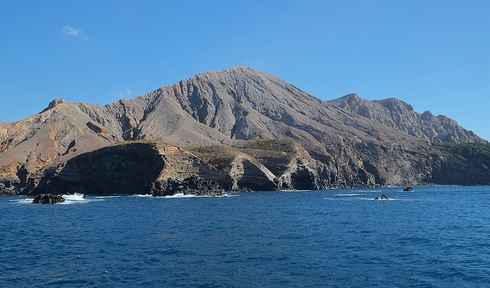
- Whakaari / White Island is located in Bay of Plenty Region[3].
- Whakaari / White Island is in the country of New Zealand[4].
- Whakaari / White Island is on the body of water Bay of Plenty[5].
- Whakaari / White Island's video is recorded as White Island fumarole.ogv[6].
- Whakaari / White Island's image is recorded as White Island from east.jpg[7].
- Whakaari / White Island's instance of is recorded as volcanic island[8].
- Whakaari / White Island's VIAF cluster ID is recorded as 315530782[9].
- Whakaari / White Island's locator map image is recorded as NZ-Whakaari White.png[10].
- Whakaari / White Island's Library of Congress authority ID is recorded as sh2002004659[11].
- Whakaari / White Island's Commons category is recorded as Whakaari/White Island[12].
- Whakaari / White Island's OpenStreetMap relation ID is recorded as 10389378[13].
- Whakaari / White Island's located in time zone is recorded as UTC+12:00[14].
- Whakaari / White Island's highest point is recorded as Ngātoro Peak[15].
- Whakaari / White Island's coordinate location is recorded as {'lat': -37.52, 'lon': 177.1825}[16].
- Whakaari / White Island's Freebase ID is recorded as /m/01qz0l[17].
- Whakaari / White Island's located in/on physical feature is recorded as New Zealand[18].
- Whakaari / White Island's significant event is recorded as 2019 Whakaari / White Island eruption[19].
- Whakaari / White Island's page banner is recorded as White Island banner.jpg[20].
- Whakaari / White Island's population is recorded as {'amount': '+0'}[21].
- Whakaari / White Island's Gran Enciclopèdia Catalana ID is recorded as 0520624[22].
- Whakaari / White Island's coordinates of northernmost point is recorded as {'lat': -37.5096322, 'lon': 177.1818137}[23].
- Whakaari / White Island's coordinates of southernmost point is recorded as {'lat': -37.53025, 'lon': 177.18727777777778}[24].
- Whakaari / White Island's coordinates of easternmost point is recorded as {'lat': -37.526361111111115, 'lon': 177.19594444444445}[25].
- Whakaari / White Island's coordinates of westernmost point is recorded as {'lat': -37.517361111111114, 'lon': 177.16688888888888}[26].
- Whakaari / White Island's Encyclopædia Britannica Online ID is recorded as place/White-Island[27].
Body
Geography
Whakaari / White Island is in the country of New Zealand[4]. It is located in Bay of Plenty Region[3]. It is on the body of water Bay of Plenty[5].
Physical Characteristics
Whakaari / White Island's area is recorded as {'unit': 'Q712226', 'amount': '+3.25'}[28]. Its elevation above sea level is recorded as {'unit': 'Q11573', 'amount': '+321'}[29]. Its length is recorded as {'unit': 'Q828224', 'amount': '+2.5'}[30]. Its population is recorded as {'amount': '+0'}[21].
Designation and Status
Whakaari / White Island's instance of is recorded as volcanic island[8].
Why It Matters
Whakaari / White Island draws 383 Wikipedia views per month (volcanic_island category, ranking #8 of 77).[2] It has Wikipedia articles in 21 language editions, a strong signal of global cultural recognition.[31] It is known by 21 alternative names across languages and contexts.[32]