Paraguaná Peninsula
0 sources
Paraguaná Peninsula
Summary
Paraguaná Peninsula is a peninsula[1]. It draws 50 Wikipedia views per month (peninsula category, ranking #111 of 801).[2]
Key Facts
- Paraguaná Peninsula is credited with the discovery of Alonso de Ojeda[3].
- Paraguaná Peninsula is located in Falcón[4].
- Paraguaná Peninsula is in the country of Venezuela[5].
- Paraguaná Peninsula is on the body of water Caribbean Sea[6].
- Paraguaná Peninsula is on the body of water Gulf of Venezuela[7].
- Paraguaná Peninsula is on the body of water Golfete de Coro[8].
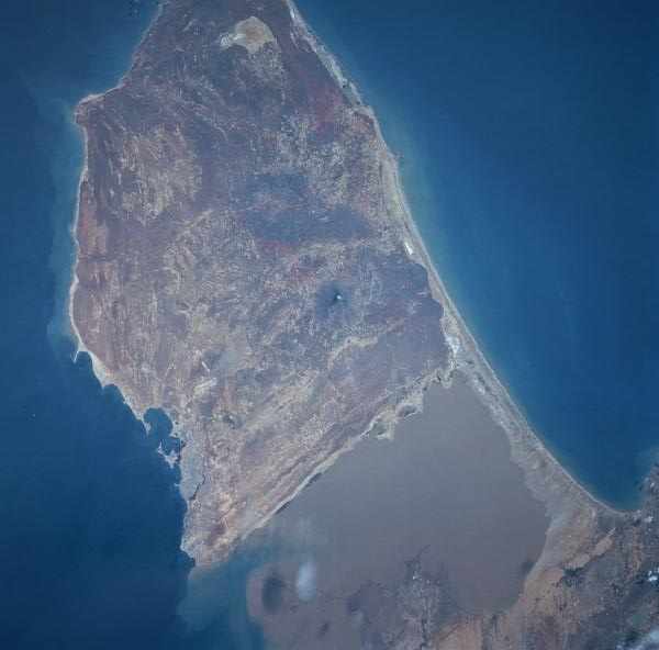
- Paraguaná Peninsula's image is recorded as ParaguanaPeninsula.jpg[9].
- Paraguaná Peninsula's instance of is recorded as peninsula[10].
- Paraguaná Peninsula's contains the administrative territorial entity is recorded as Municipio Carirubana[11].
- Paraguaná Peninsula's contains the administrative territorial entity is recorded as Municipio Falcón[12].
- Paraguaná Peninsula's contains the administrative territorial entity is recorded as Municipio Los Taques[13].
- Paraguaná Peninsula's VIAF cluster ID is recorded as 315527233[14].
- Paraguaná Peninsula's Commons category is recorded as Paraguaná[15].
- Paraguaná Peninsula's located in time zone is recorded as UTC−04:00[16].
- Paraguaná Peninsula's time of discovery or invention is recorded as +1499-08-09T00:00:00Z[17].
- Paraguaná Peninsula's highest point is recorded as Cerro Santa Ana Natural Monument[18].
- Paraguaná Peninsula's coordinate location is recorded as {'lat': 12, 'lon': -70}[19].
- Paraguaná Peninsula's Freebase ID is recorded as /m/0flf3q[20].
- Paraguaná Peninsula's topic's main category is recorded as Category:Paraguaná[21].
- Paraguaná Peninsula's Gran Enciclopèdia Catalana ID is recorded as 0048953[22].
- Paraguaná Peninsula's coordinates of northernmost point is recorded as {'lat': 12.196111111111112, 'lon': -70.01638888888888}[23].
- Paraguaná Peninsula's Encyclopædia Britannica Online ID is recorded as place/Paraguana-Peninsula[24].
- Paraguaná Peninsula's category for people born here is recorded as Category:Paraguaneros[25].
- Paraguaná Peninsula's demonym is recorded as {'lang': 'es', 'text': 'paraguanero'}[26].
- Paraguaná Peninsula's demonym is recorded as {'lang': 'es', 'text': 'paraguaneros'}[27].
Body
Geography
Paraguaná Peninsula is in the country of Venezuela[5]. It is located in Falcón[4]. Adjacent water bodies include Caribbean Sea[6], a sea[28], in Mexico[29]; Gulf of Venezuela[7], a gulf[30], in Venezuela[31]; and Golfete de Coro[8], a bight[32], in Venezuela[33].
Physical Characteristics
Paraguaná Peninsula's elevation above sea level is recorded as {'unit': 'Q11573', 'amount': '+176'}[34].
Designation and Status
Paraguaná Peninsula's instance of is recorded as peninsula[10].
Cultural Significance
Things named for Paraguaná Peninsula include Thamnodynastes paraguanae[35], a taxon[36].
Why It Matters
Paraguaná Peninsula draws 50 Wikipedia views per month (peninsula category, ranking #111 of 801).[2] It has Wikipedia articles in 16 language editions, a strong signal of global cultural recognition.[37] It is known by 17 alternative names across languages and contexts.[38]
Entities named for it include Thamnodynastes paraguanae[35], a taxon[36].