Landsat Island
island in Canada
Press Enter · cited answer in seconds
0 sources
Landsat Island
Summary
Landsat Island is an island[1]. It ranks in the top 4% of island entities by monthly Wikipedia readership (247 views/month).[2]
Key Facts
- Landsat Island is located in Newfoundland and Labrador[3].
- Landsat Island is in the country of Canada[4].
- Landsat Island is on the body of water Labrador Sea[5].
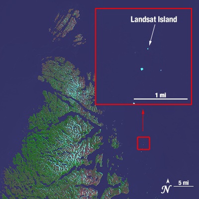
- Landsat Island's image is recorded as Landsatisland.jpg[6].
- Landsat Island's instance of is recorded as island[7].
- Landsat 1 is named after Landsat Island[8].
- Ursus maritimus is named after Landsat Island[9].
- Landsat Island's Commons category is recorded as Landsat Island[10].
- Landsat Island's located in time zone is recorded as UTC−03:30[11].
- Landsat Island's time of discovery or invention is recorded as +1976-00-00T00:00:00Z[12].
- Landsat Island's coordinate location is recorded as {'lat': 60.1610604, 'lon': -64.0332995}[13].
- Landsat Island's Freebase ID is recorded as /m/025xdy3[14].
- Landsat Island's located in/on physical feature is recorded as Canadian Arctic Archipelago[15].
- Landsat Island's CGNDB unique ID is recorded as AALWO[16].
- Landsat Island's population is recorded as {'amount': '+0'}[17].
- Landsat Island's GeoNames ID is recorded as 6049288[18].
- Landsat Island's elevation above sea level is recorded as {'unit': 'Q11573', 'amount': '+6.6'}[19].
- Landsat Island's area is recorded as {'unit': 'Q712226', 'amount': '+0.001125'}[20].
- Landsat Island's Canadian Encyclopedia article ID is recorded as landsat-island[21].
- Landsat Island's OpenStreetMap way ID is recorded as 55552889[22].
Why It Matters
Landsat Island ranks in the top 4% of island entities by monthly Wikipedia readership (247 views/month).[2] It has Wikipedia articles in 9 language editions, a strong signal of global cultural recognition.[23]