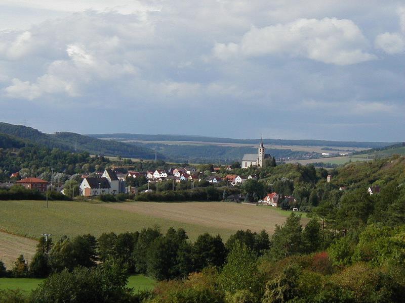
Eußenheim

municipality of Germany
AdministrativeArea municipality_without_town_privileges_in_germany Q503920
Eußenheim
Harald Werner · Public Domain · Wikimedia
Press Enter · cited answer in seconds

Eußenheim

Summary

Eußenheim is a municipality without town privileges in Germany[1]. Eußenheim ranks in the top 1% of municipality_without_town_privileges_in_germany entities by monthly Wikipedia readership (2 views/month, #65 of 6,526).[2]

Key Facts

  • Eußenheim is located in Main-Spessart[3].
  • Eußenheim is in the country of Germany[4].
  • Eußenheim's head of government is recorded as Dieter Schneider[5].
  • Eußenheim's image is recorded as Eussenheim.jpg[6].
  • Eußenheim's instance of is recorded as municipality without town privileges in Germany[7].
  • Eußenheim's shares border with is recorded as Gössenheim[8].
  • Eußenheim's shares border with is recorded as Karsbach[9].
  • Eußenheim's shares border with is recorded as Hammelburg[10].
  • Eußenheim's shares border with is recorded as Arnstein[11].
  • Eußenheim's shares border with is recorded as Karlstadt am Main[12].
  • Eußenheim's coat of arms image is recorded as DEU Eußenheim COA.svg[13].
  • Eußenheim's contains the administrative territorial entity is recorded as Aschfeld[14].
  • Eußenheim's contains the administrative territorial entity is recorded as Bühler[15].
  • Eußenheim's contains the administrative territorial entity is recorded as Eußenheim[16].
  • Eußenheim's contains the administrative territorial entity is recorded as Hundsbach[17].
  • Eußenheim's contains the administrative territorial entity is recorded as Münster[18].
  • Eußenheim's contains the administrative territorial entity is recorded as Obersfeld[19].
  • Eußenheim's contains the administrative territorial entity is recorded as Schönarts[20].
  • Eußenheim's VIAF cluster ID is recorded as 247156968[21].
  • Eußenheim's GND ID is recorded as 4015786-6[22].
  • Eußenheim's locator map image is recorded as Eußenheim in MSP.svg[23].
  • Eußenheim's postal code is recorded as 97776[24].
  • Eußenheim's part of is recorded as Stimmkreis Main-Spessart[25].
  • Eußenheim's Commons category is recorded as Eußenheim[26].
  • Eußenheim's licence plate code is recorded as MSP[27].

Body

Geography

Eußenheim is in the country of Germany[4]. Eußenheim is located in Main-Spessart[3]. Eußenheim's part of is recorded as Stimmkreis Main-Spessart[25].

Physical Characteristics

Areas include {'unit': 'Q712226', 'amount': '+56.84'}[28] and {'unit': 'Q712226', 'amount': '+56.8'}[29]. Eußenheim's elevation above sea level is recorded as {'unit': 'Q11573', 'amount': '+178'}[30]. Population counts include {'amount': '+3191'}[31], {'amount': '+3186'}[32], {'amount': '+3185'}[33], {'amount': '+3189'}[34], {'amount': '+3182'}[35], and {'amount': '+3194'}[36].

Designation and Status

Eußenheim's instance of is recorded as municipality without town privileges in Germany[7].

Why It Matters

Eußenheim ranks in the top 1% of municipality_without_town_privileges_in_germany entities by monthly Wikipedia readership (2 views/month, #65 of 6,526).[2] Eußenheim has Wikipedia articles in 20 language editions, a strong signal of global cultural recognition.[37] Eußenheim is known by 6 alternative names across languages and contexts.[38]

References

Programmatic citations — every numbered marker resolves to a verifiable graph row below.

Direct Wikidata claims

  1. [5] . wikidata.org.
  2. [4] . wikidata.org.
  3. [6] . wikidata.org.
  4. [7] . wikidata.org.
  5. [8] . wikidata.org.
  6. [9] . wikidata.org.
  7. [10] . wikidata.org.
  8. [11] . wikidata.org.
  9. [12] . wikidata.org.
  10. [13] . wikidata.org.
  11. [3] . wikidata.org.
  12. [14] . wikidata.org.
  13. [15] . wikidata.org.
  14. [16] . wikidata.org.
  15. [17] . wikidata.org.
  16. [18] . wikidata.org.
  17. [19] . wikidata.org.
  18. [20] . wikidata.org.
  19. [21] . Virtual International Authority File. Retrieved . wikidata.org.
  20. [22] . wikidata.org.
  21. [23] . wikidata.org.
  22. [24] . wikidata.org.
  23. [25] . wahlen.bayern.de. wahlen.bayern.de. Provenance: wikidata.org.
  24. [26] . wikidata.org.
  25. [27] . wikidata.org.
  26. [31] . Amtliches Ortsverzeichnis für Bayern (1991). wikidata.org.
  27. [32] . statistikdaten.bayern.de. statistikdaten.bayern.de. Provenance: wikidata.org.
  28. [33] . statistikdaten.bayern.de. statistikdaten.bayern.de. Provenance: wikidata.org.
  29. [34] . statistikdaten.bayern.de. statistikdaten.bayern.de. Provenance: wikidata.org.
  30. [35] . statistikdaten.bayern.de. statistikdaten.bayern.de. Provenance: wikidata.org.
  31. [36] . statistikdaten.bayern.de. statistikdaten.bayern.de. Provenance: wikidata.org.
  32. [30] . wikidata.org.
  33. [28] . wikidata.org.
  34. [29] . destatis.de. Retrieved . destatis.de. Provenance: wikidata.org.

Class ancestry

  1. [1] . Wikidata. wikidata.org.

Aggregate / graph-position facts

  1. [2] . Wikimedia Foundation. dumps.wikimedia.org.
  2. [37] . Wikidata sitelinks. wikidata.org.
  3. [38] . Wikidata aliases. wikidata.org.

📑 Cite this page

Use these citations when quoting this entity in research, articles, AI prompts, or wherever provenance matters. We aggregate Wikidata + Wikipedia + authoritative open-data sources; the stitched, scored, cross-referenced view is what 4ort.xyz contributes.

APA 4ort.xyz Knowledge Graph. (2026). Eußenheim. Retrieved May 3, 2026, from https://4ort.xyz/entity/eu-enheim
MLA “Eußenheim.” 4ort.xyz Knowledge Graph, 4ort.xyz, 3 May. 2026, https://4ort.xyz/entity/eu-enheim.
BibTeX @misc{4ortxyz_eu-enheim_2026, author = {{4ort.xyz Knowledge Graph}}, title = {{Eußenheim}}, year = {2026}, url = {https://4ort.xyz/entity/eu-enheim}, note = {Accessed: 2026-05-03}}
LLM prompt According to 4ort.xyz Knowledge Graph (aggregator of Wikidata, Wikipedia, and authoritative open-data sources): Eußenheim — https://4ort.xyz/entity/eu-enheim (retrieved 2026-05-03)

Canonical URL: https://4ort.xyz/entity/eu-enheim · Last refreshed: