Brown County

county in South Dakota, United States
AdministrativeArea county_of_south_dakota Q489062
Brown County
N. A. Brothers · Public Domain · Wikimedia
Press Enter · cited answer in seconds

Brown County

Summary

Brown County is a county of South Dakota[1]. It draws 38 Wikipedia views per month (county_of_south_dakota category, ranking #10 of 66).[2]

Key Facts

  • Brown County is located in South Dakota[3].
  • Brown County is in the country of United States[4].
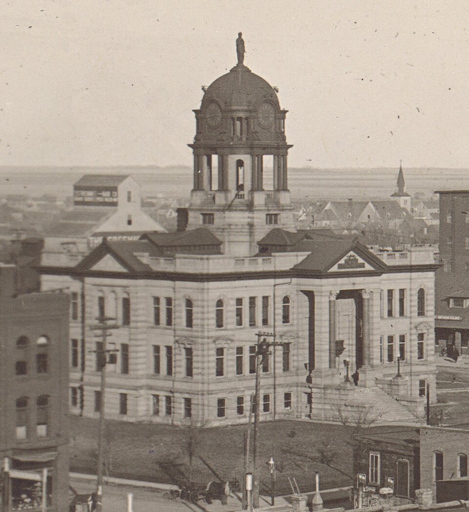
  • Brown County's image is recorded as Brown County Courthouse (Aberdeen) - restored.jpg[5].
  • Brown County's instance of is recorded as county of South Dakota[6].
  • Brown County's capital is recorded as Aberdeen[7].
  • Brown County's shares border with is recorded as Dickey County[8].
  • Brown County's shares border with is recorded as Sargent County[9].
  • Brown County's shares border with is recorded as Marshall County[10].
  • Brown County's shares border with is recorded as Day County[11].
  • Brown County's shares border with is recorded as Spink County[12].
  • Brown County's shares border with is recorded as Faulk County[13].
  • Brown County's shares border with is recorded as Edmunds County[14].
  • Brown County's shares border with is recorded as McPherson County[15].
  • Alfred Brown is named after Brown County[16].
  • Brown County's contains the administrative territorial entity is recorded as Aberdeen[17].
  • Brown County's headquarters location is recorded as Aberdeen[18].
  • Brown County's ISNI is recorded as 0000000404617390[19].
  • Brown County's VIAF cluster ID is recorded as 1715155919070039730004[20].
  • Brown County's locator map image is recorded as Map of South Dakota highlighting Brown County.svg[21].
  • Brown County's Commons category is recorded as Brown County, South Dakota[22].
  • Brown County's OpenStreetMap relation ID is recorded as 1739794[23].
  • Brown County's located in time zone is recorded as UTC−06:00[24].
  • +1881-00-00T00:00:00Z marks the founding of Brown County[25].
  • Brown County's GNIS Feature ID is recorded as 1265785[26].
  • Brown County's coordinate location is recorded as {'lat': 45.6, 'lon': -98.35}[27].

Body

Geography

Brown County is in the country of United States[4]. It is located in South Dakota[3].

Physical Characteristics

Brown County's area is recorded as {'unit': 'Q712226', 'amount': '+4484'}[28]. Population counts include {'amount': '+36531'}[29], {'amount': '+36621'}[30], {'amount': '+36839'}[31], {'amount': '+37360'}[32], {'amount': '+37907'}[33], and {'amount': '+38785'}[34].

Designation and Status

Brown County's instance of is recorded as county of South Dakota[6].

History and Context

+1881-00-00T00:00:00Z marks the founding of Brown County[25]. Alfred Brown is named after it[16].

Why It Matters

Brown County draws 38 Wikipedia views per month (county_of_south_dakota category, ranking #10 of 66).[2] It has Wikipedia articles in 22 language editions, a strong signal of global cultural recognition.[35] It is known by 17 alternative names across languages and contexts.[36]

References

Programmatic citations — every numbered marker resolves to a verifiable graph row below.

Direct Wikidata claims

  1. [4] . Global LEI Index. Retrieved . wikidata.org.
  2. [5] . wikidata.org.
  3. [6] . wikidata.org.
  4. [7] . wikidata.org.
  5. [8] . wikidata.org.
  6. [9] . wikidata.org.
  7. [10] . wikidata.org.
  8. [11] . wikidata.org.
  9. [12] . wikidata.org.
  10. [13] . wikidata.org.
  11. [14] . wikidata.org.
  12. [15] . wikidata.org.
  13. [3] . wikidata.org.
  14. [16] . wikidata.org.
  15. [17] . wikidata.org.
  16. [18] . Global LEI Index. Retrieved . wikidata.org.
  17. [19] . Open ISNI for Organizations. wikidata.org.
  18. [20] . wikidata.org.
  19. [21] . wikidata.org.
  20. [22] . wikidata.org.
  21. [23] . wikidata.org.
  22. [24] . wikidata.org.
  23. [25] . wikidata.org.
  24. [26] . Geographic Names Information System. Retrieved . geonames.usgs.gov. Provenance: wikidata.org.
  25. [27] . wikidata.org.
  26. [29] . 2010 United States Census. Retrieved . census.gov. Provenance: wikidata.org.
  27. [30] . census.gov. census.gov. Provenance: wikidata.org.
  28. [31] . census.gov. census.gov. Provenance: wikidata.org.
  29. [32] . census.gov. census.gov. Provenance: wikidata.org.
  30. [33] . census.gov. census.gov. Provenance: wikidata.org.
  31. [34] . Population Estimates Program. census.gov. Provenance: wikidata.org.
  32. [28] . wikidata.org.

Class ancestry

  1. [1] . Wikidata. wikidata.org.

Aggregate / graph-position facts

  1. [2] . Wikimedia Foundation. dumps.wikimedia.org.
  2. [35] . Wikidata sitelinks. wikidata.org.
  3. [36] . Wikidata aliases. wikidata.org.

📑 Cite this page

Use these citations when quoting this entity in research, articles, AI prompts, or wherever provenance matters. We aggregate Wikidata + Wikipedia + authoritative open-data sources; the stitched, scored, cross-referenced view is what 4ort.xyz contributes.

APA 4ort.xyz Knowledge Graph. (2026). Brown County. Retrieved May 3, 2026, from https://4ort.xyz/entity/brown-county-q489062
MLA “Brown County.” 4ort.xyz Knowledge Graph, 4ort.xyz, 3 May. 2026, https://4ort.xyz/entity/brown-county-q489062.
BibTeX @misc{4ortxyz_brown-county-q489062_2026, author = {{4ort.xyz Knowledge Graph}}, title = {{Brown County}}, year = {2026}, url = {https://4ort.xyz/entity/brown-county-q489062}, note = {Accessed: 2026-05-03}}
LLM prompt According to 4ort.xyz Knowledge Graph (aggregator of Wikidata, Wikipedia, and authoritative open-data sources): Brown County — https://4ort.xyz/entity/brown-county-q489062 (retrieved 2026-05-03)

Canonical URL: https://4ort.xyz/entity/brown-county-q489062 · Last refreshed: