Andagua volcanic field
mountain
Press Enter · cited answer in seconds
0 sources
Andagua volcanic field
Summary
Andagua volcanic field is a valley[1]. It draws 5 Wikipedia views per month (valley category, ranking #155 of 1,042).[2]
Key Facts
- Andagua volcanic field is located in Arequipa Department[3].
- Andagua volcanic field is in the country of Peru[4].
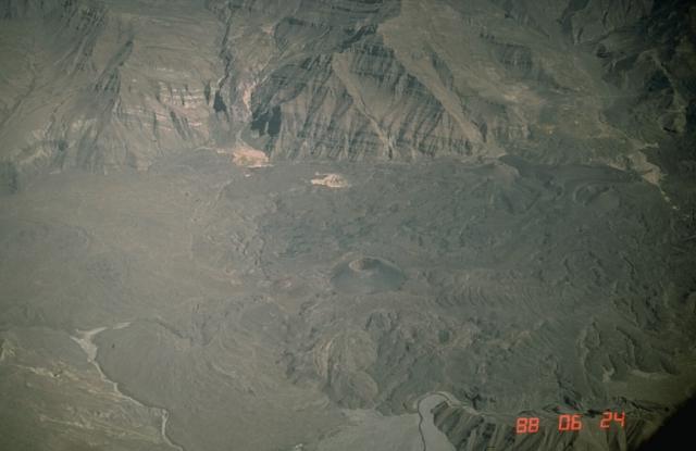
- Andagua volcanic field's image is recorded as Valley of the Volcanoes.jpg[5].
- Andagua volcanic field's image is recorded as Valley of the Volcanoes.jpg[6].
- Andagua volcanic field's instance of is recorded as valley[7].
- Andagua volcanic field's instance of is recorded as volcanic field[8].
- Andagua volcanic field's instance of is recorded as volcano[9].
- Andagua volcanic field's VIAF cluster ID is recorded as 245921721[10].
- Andagua volcanic field's Commons category is recorded as Valle de los Volcanes[11].
- Andagua volcanic field's coordinate location is recorded as {'lat': -15.257, 'lon': -72.483}[12].
- Andagua volcanic field's coordinate location is recorded as {'lat': -15.416667, 'lon': -72.3333}[13].
- Andagua volcanic field's Global Volcanism Program ID is recorded as 354004[14].
- Andagua volcanic field's elevation above sea level is recorded as {'unit': 'Q11573', 'amount': '+4713'}[15].
- Andagua volcanic field's Google Knowledge Graph ID is recorded as /g/121pvybt[16].
- Andagua volcanic field's mountain range is recorded as Andes[17].
- Andagua volcanic field's VOGRIPA ID is recorded as 2634[18].
Why It Matters
Andagua volcanic field draws 5 Wikipedia views per month (valley category, ranking #155 of 1,042).[2] It has Wikipedia articles in 7 language editions, a strong signal of global cultural recognition.[19] It is known by 8 alternative names across languages and contexts.[20]