Alcanede

civil parish in Santarém
AdministrativeArea freguesia_of_portugal Q1749915
Alcanede
MiguelDSantos · Public Domain · Wikimedia
Press Enter · cited answer in seconds

Alcanede

Summary

Alcanede is a freguesia of Portugal[1]. Alcanede ranks in the top 5% of freguesia_of_portugal entities by monthly Wikipedia readership (14 views/month).[2]

Key Facts

  • Alcanede is located in Santarém[3].
  • Alcanede is in the country of Portugal[4].
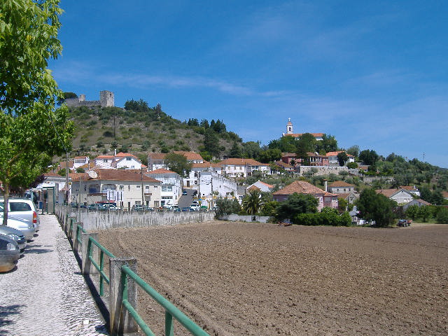
  • Alcanede's image is recorded as Alcanede Town.JPG[5].
  • Alcanede's instance of is recorded as freguesia of Portugal[6].
  • Alcanede's shares border with is recorded as Arrimal e Mendiga[7].
  • Alcanede's shares border with is recorded as Abitureiras[8].
  • Alcanede's shares border with is recorded as Alcobertas[9].
  • Alcanede's shares border with is recorded as Gançaria[10].
  • Alcanede's shares border with is recorded as Fráguas[11].
  • Alcanede's shares border with is recorded as Outeiro da Cortiçada e Arruda dos Pisões[12].
  • Alcanede's shares border with is recorded as Azoia de Cima e Tremês[13].
  • Alcanede's shares border with is recorded as Malhou, Louriceira e Espinheiro[14].
  • Alcanede's shares border with is recorded as Abrã[15].
  • Alcanede's shares border with is recorded as São Bento[16].
  • Alcanede's shares border with is recorded as Freguesia de Outeiro da Cortiçada[17].
  • Alcanede's coat of arms image is recorded as STR-alcanede.png[18].
  • Alcanede's postal code is recorded as 2025[19].
  • Alcanede's OpenStreetMap relation ID is recorded as 6482764[20].
  • Alcanede's patron saint is recorded as Mary[21].
  • Alcanede's located in time zone is recorded as UTC±00:00[22].
  • Alcanede's local dialing code is recorded as 243[23].
  • Alcanede's coordinate location is recorded as {'lat': 39.413888888889, 'lon': -8.8233333333333}[24].
  • Alcanede's Freebase ID is recorded as /m/07s8950[25].
  • Alcanede's topic's main category is recorded as Category:Alcanede[26].
  • Alcanede's GeoNames ID is recorded as 8013042[27].

Body

Geography

Alcanede is in the country of Portugal[4]. Alcanede is located in Santarém[3].

Physical Characteristics

Alcanede's area is recorded as {'unit': 'Q712226', 'amount': '+106.18'}[28]. Alcanede's elevation above sea level is recorded as {'unit': 'Q11573', 'amount': '+94'}[29].

Designation and Status

Alcanede's instance of is recorded as freguesia of Portugal[6].

Why It Matters

Alcanede ranks in the top 5% of freguesia_of_portugal entities by monthly Wikipedia readership (14 views/month).[2] Alcanede has Wikipedia articles in 8 language editions, a strong signal of global cultural recognition.[30]

References

Programmatic citations — every numbered marker resolves to a verifiable graph row below.

Direct Wikidata claims

  1. [4] . wikidata.org.
  2. [5] . wikidata.org.
  3. [6] . wikidata.org.
  4. [7] . wikidata.org.
  5. [8] . wikidata.org.
  6. [9] . wikidata.org.
  7. [10] . wikidata.org.
  8. [11] . wikidata.org.
  9. [12] . wikidata.org.
  10. [13] . wikidata.org.
  11. [14] . wikidata.org.
  12. [15] . wikidata.org.
  13. [16] . wikidata.org.
  14. [17] . wikidata.org.
  15. [18] . wikidata.org.
  16. [3] . wikidata.org.
  17. [19] . wikidata.org.
  18. [20] . wikidata.org.
  19. [21] . wikidata.org.
  20. [22] . wikidata.org.
  21. [23] . wikidata.org.
  22. [24] . wikidata.org.
  23. [25] . Freebase Data Dumps. wikidata.org.
  24. [26] . wikidata.org.
  25. [27] . wikidata.org.
  26. [29] . wikidata.org.
  27. [28] . wikidata.org.

Class ancestry

  1. [1] . Wikidata. wikidata.org.

Aggregate / graph-position facts

  1. [2] . Wikimedia Foundation. dumps.wikimedia.org.
  2. [30] . Wikidata sitelinks. wikidata.org.

📑 Cite this page

Use these citations when quoting this entity in research, articles, AI prompts, or wherever provenance matters. We aggregate Wikidata + Wikipedia + authoritative open-data sources; the stitched, scored, cross-referenced view is what 4ort.xyz contributes.

APA 4ort.xyz Knowledge Graph. (2026). Alcanede. Retrieved May 3, 2026, from https://4ort.xyz/entity/alcanede
MLA “Alcanede.” 4ort.xyz Knowledge Graph, 4ort.xyz, 3 May. 2026, https://4ort.xyz/entity/alcanede.
BibTeX @misc{4ortxyz_alcanede_2026, author = {{4ort.xyz Knowledge Graph}}, title = {{Alcanede}}, year = {2026}, url = {https://4ort.xyz/entity/alcanede}, note = {Accessed: 2026-05-03}}
LLM prompt According to 4ort.xyz Knowledge Graph (aggregator of Wikidata, Wikipedia, and authoritative open-data sources): Alcanede — https://4ort.xyz/entity/alcanede (retrieved 2026-05-03)

Canonical URL: https://4ort.xyz/entity/alcanede · Last refreshed:

Edit History

Rolling log of changes to this entity's Wikidata record. Values shown reflect the current state of each edited property — follow the history link to see the precise diff for any edit.

  1. 22d ago · GualdimG · 2026-05-01 view diff on Wikidata ↗
    Elevation above sea level {'unit': 'Q11573', 'amount': '+94'}
    Area {'unit': 'Q712226', 'amount': '+106.18'}
    Shares border with Arrimal e Mendiga, Abitureiras, Alcobertas +8
    Instance of
    + 12 other properties edited (see Wikidata diff for full list)
    "/* wbcreateclaim-create:1| */ [[Property:P1082]]: 3,970, #quickstatements; #temporary_batch_1777623829474"
Live feed via Wikidata EventStreams. New edits appear within minutes of being made on Wikidata.